
- Client – Antragrafik Systems Sdn. Bhd.
- Project Duration – 6 months
- Delivery – GIS Web Application
Our client’s requirement is to collect MV Poles in northern Malaysia using handheld GPS device. The client will give the source and destination substations coordinate and substation name in a spatial format, our team will strategize the route planning and assign to the field data collection team. The FDC will visit each pole and record it’s coordinates and pole number in a GPS device. The project coordinator will assign the data to the GIS Executive system team to do the GPS Processing, Validation and perform Quality checks before delivery.
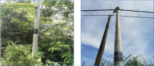
The web application speed up the delivery of data by 3x than the manual process and were able to complete over 150,000 poles in 3 months.The web application will also auto quality check the pole is within the 0.5 m from the road distance.
admin
March 11, 2018The recording starts with the patter of a summer squall. Later, a drifting tone like that of a not-quite-tuned-in radio station rises and for a while drowns out the patter.
admin
October 24, 2018Some need to protect very valuable information. All these factors should be taken into account.
admin
October 24, 2018All these factors should be taken into account. A risk-aware Windows user can probably survive without any anti-virus software at all.
admin
October 23, 2018The Rangers needed a jolt for their first home game of their second-round series against the Ottawa Senators. Turning to Tanner Glass and his physical style.